Vegetation
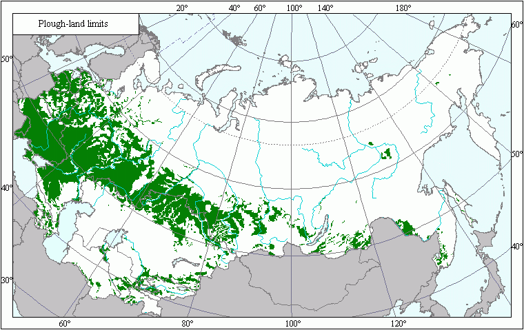
Boundaries of Arable Land .
 Download GIS-layers
Authors:
Scientists - Rukhovich, D.I., Vilchevskaya, Е.V.Date of creation:
10.07.2003.Scale:
10 km/pixAccuracy of map:
Map contains information on arable lands for patches of the Earth's surface with an area of 10 x 10 km. The arable land layer for the USSR territory was obtained by carrying out an overlay reduction of the 1:4 000,000 land resources map to a scale of 1:20,000,000.Projection:
"Alber.s Equal Area for the USSR":ref. system : Alber.s Equal Area Conic for Russia
projection : Alber.s Equal Area Conic
datum : Pulkovo 1942 (S42)
delta WGS84 : 28 -130 -95
ellipsoid : Krasovsky
major s-ax : 6378245.000
minor s-ax : 6356863.019
origin long : 100
origin lat : 0
origin X : 0
origin Y : 0
scale fac : na
units : m
parameters : 2
stand ln 1 : 44
stand ln 2 : 68
Basic contents:
Raster map. Consists of information about presence or absence of arable land.Accuracy of classifier:
Raster map with following classes: 0 . uncultivated land; 1- arable land; 100 - territories outside the map.Method of map production:
Arable lands layer for the USSR territory was obtained by carrying out an overlay reduction of the 1:4 000,000 land resources map to the scale of 1:20,000,000, setting off areas where a minimum of 10 % of lands are tilled.Reference citations:
Koroljeva IE, Vilchevskaya EV, Ruhovich DI. 2003. Digital Arable Land Map.Laboratory of Soil Information of the Dokuchaev Soil Institute, Moscow, Russia
[Based on: Yanvareva LF. (ed.), Martynjuk KN., Kisileva NM. 1989. Map of Land
Use, Faculty of Geography, Moscow State University, Moscow, Russia.].