Relatives
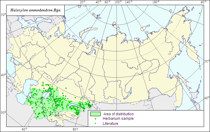
Range of distribution of Saxaul, Saksaul (Haloxylon ammodendron (C.A.Mey) Bunge).
 Object description Download GIS-layers
Authors:
The expert-botanists - N.I.Dzyubenko, E.A.Dzyubenko.The GIS expert - A.N.Dzyubenko.
Date of creation:
17.09.2007Scale:
1:20 000 000.Accuracy of the map:
The map is based on data of a 1:25 000 000 scale map, specified according to herbarium materials.Projection:
"Albers Equal-Area Conic Projection for USSR", 9, 1001, 7, 100, 0, 44, 68, 0, 0Basic contents:
The map is a vector file consisting of 1 basic and 2 subject layers. The species range is represented by a polygon and dots.Accuracy of the qualifier:
The dots represent information on the species localities: reliable data according to herbarium (1) and published sources (2); the polygon (1) - generalized information on the species distribution from published sources and herbarium specimens.Method of the map construction:
The data from the herbarium materials of LE, a published map of the range (Sokolov, et al., 1980), and published data (Iljin, 1936) were used for constructing the range of Haloxylon ammodendron. The range consists of one polygon and dots. The species is confined to the deserts of the Central Asia, especially abundant in the east; i.e., in Balkhash Lake area where it forms saxaul woodlands on sands together with other saxaul species.References:
Sokolov SI., Svjaseva OA., Kubli VA. 1980. Ranges of trees and shrubs of the USSR. V.2. Leningrad: Nauka. 144 p. Map 8a. (In Russian).Iljin MM. 1936. Genus Saxaul - Haloxylon Bge. In: Shishkin BK., ed. Flora URSS. V.6. Moscow; Leningrad. P.310-314. (In Russian).
Herbarium specimens of V.L.Komarov Botanical Institute [LE], St.Petersburg, Russia.
Rights and copyrights:
The copyrights of the map and descriptions are held by their authors.The copyright of the photo is held by E.A.Dzyubenko.