Relatives
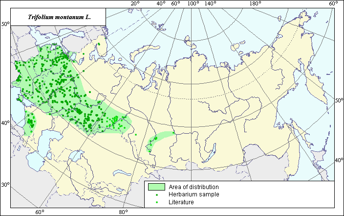
Area of Mountain Clover (Trifolium montanum L.).
 Object description Download GIS-layers
Authors:
The experts - Dzyubenko N.I., E.A. Dzyubenko.The GIS-Expert - Dzyubenko A.N.
Date of creation:
17.12.2004Scale:
1:20 000 000Accuracy of the map:
The map was created using maps that had the following scale 1:10 000 000 - 1:60 000 000.The projection:
"Alber's Equal Area Conic for Russia", 9, 1001, 7, 100, 0, 44, 68, 0, 0Basic contents:
Vector map. Area of species distribution is shown by polygons and actual location occurrence is shown by points.Accuracy of classifier:
Point data were obtained from literature sources and herbarium specimens. Light-colored points represent locations referenced in literature sources. Dark-colored points represent locations of the species that were reported from the in-house database of VIR (N.I. Vavilov All-Russian Research Institute of Plant Industry) and BIN (V.L. Komarov Institute of Botany). Polygons are based on literature sources, herbarium samples, and field surveys by the authors.Method of map production:
Published literature was reviewed, including Atlases, monographs and papers. Occurrence data were obtained from herbarium specimens, floras, monographs and papers. For the construction of the area of Trifolium montanum the following published maps were used: Grossheim (1952), Mosel (1965), Polozhiy & Malyshev (1994), V.L. Komarov Botanical Institute, N.I. Vavilov All Russian Institute of Plant Industry. Our point of view as to the distribution of the species in the territory of Russia and adjacent states completely coincides with the understanding of the area of the species by Mosel (1965). The definition of the area border is based on all available data which have no significant contradictions. The area has a disjunctive character and consists of three polygons and separate isolated points. The largest polygon includes the territory of the European part of former USSR (all regions except north), Crimea (mountain part), Western Siberia (southern part) and Kazakhstan (north and north western part). Within the limits of the Caucasian polygon the distribution of the species from the south-east and the south-west is limited by the Kholhid floristic provintion. Data were compiled through scanning and geo-referencing to develop a composite vector map. The biologist, together with the GIS specialist, drew a new plant distribution area based on compiled data.Reference citations:
Grossheim, A.A. 1952. Flora of the Caucasus. Genus Trifolium. Moscow-Leningrad: AN USSR. V. 5. 191-221 p. (In Russian)Mosel H. 1965. Comparative Chorology of the Flora of Central Europe. Jena. 583 p.
N.I. Vavilov All-Russian Institute of Plant Industry [WIR], St. Petersburg, Russia.
Polozhiy, A.B. & L.I. Malyshev, ed. 1994. Flora of Siberia. V. 9. Novosibirsk: Nauka. 280 pp. (In Russian)
V.L. Komarov Institute Botanical Institute [LE], St. Petersburg, Russia.