Relatives
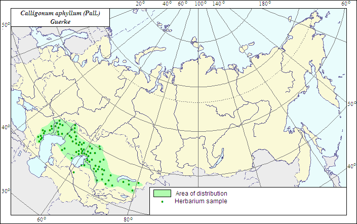
Range of distribution of Leafless Calligonum (Calligonum aphyllum) .
 Object description Download GIS-layers
Authors:
The expert-botanists - Yu.D.Soskov, L.L.MalyshevThe GIS expert - L.L.Malyshev.

RelativesRange of distribution of Leafless Calligonum (Calligonum aphyllum) . Object description Download GIS-layers Object description Download GIS-layers
Authors:The expert-botanists - Yu.D.Soskov, L.L.MalyshevThe GIS expert - L.L.Malyshev. Date of creation:25.06.2007Scale:1:20 000 000.Accuracy of the map:The map is based on data of 1:12 000 000-1:40 000 000 scale maps.Projection:"Albers Equal-Area Conic Projection for USSR", 9, 1001, 7, 100, 0, 44, 68, 0, 0Basic contents:The map is a vector file consisting of 1 basic and 2 subject layers. The species range is represented by a polygon and dots.Accuracy of the qualifier:The dots represent information on the species localities according to herbarium materials; the polygon - generalized information on the species distribution.Method of the map contruction:The range map is based on original maps compiled by the author according to herbarium materials of V.L.Komarov Botanical Institute (LE) and the Institutes of Botany of Kazakhstan (AA), Uzbekistan (TASH), Tajikistan (TAD) and Turkmenistan (ASH). The range covers the area from west to east from Caspian Lowland to Alakul Lake and the Ili River valley at 45-81° E. The range has its northern corner near Uralsk town at 51° N. This is the northernmost limit among ranges of Calligonum species. Southern borders of the range are limited by the northern Ustyurt, lower reaches of the Syr-Darya River basin (44° N), forelands of Karatau, eastward the border runs along foothills of front ranges of Tien Shan up to Panfilov town in the basin of the Ili River.References:Sokolov SI., Svjaseva OA., Kubli VA. 1980. Ranges of trees and shrubs of the USSR. V.2. Leningrad: Nauka. 144 p. (In Russian).Rights and copyrights:The copyrights of the map and descriptions are held by their authors. |
|
|
|
|
|
Web design — |