Relatives
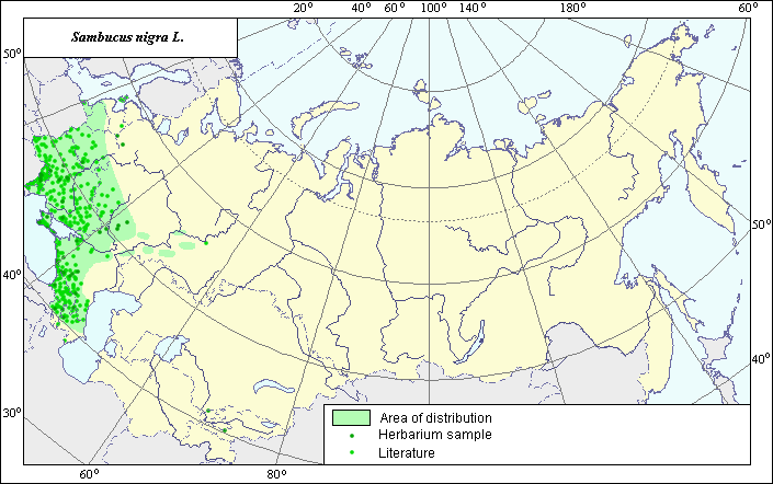
The area of Sambucus nigra L.
 Object description Download GIS-layers
Authors:
The expert-botanist - T.N. Smekalova,the GIS-expert - R.S.Ushakova.
Date of creation:
28.10.2004Scale:
1:20 000 000.Accuracy of a map:
Map is based on maps having the following scale: 1:17 000 000 - 1:80 000 000 and on data from herbarium specimans.The projection:
"Alber's Equal Area Conic for Russia", 9, 1001, 7, 100, 0, 44, 68, 0, 0Basic content:
Map is a vector fail consisting of polygon and points. Locations of species are represented by points, area of possible distribution of species are represented by polygon.Accuracy of the qualifier:
Lidht-colored points are locations referenced in literature sources. Dark-colored points are locations of species that were reported from herbarium samples (Komarov Botanical Institute, St.-Petersburg). Polygon is based on generalized information from literature sources, herbarium specimans, political boundaries and ecological description.Method of map construction:
Location and area of distribution of the species is based on published maps and analysis of herbarium materials from the Komarov Botanical Institute (BIN) (St.-Petersburg). Literature used included: "Areas of distribution of trees and shrubs in the USSR", 1980; "Atlas of medicinal plant habitats and resources in the USSR", 1983, Cherepanov (1995), Hulten, E. & Fries, M., 1986. The area of species for the investigated territory is constructed on the basis of published maps of areas of species (Hulten, E. & Fries, M., 1986; "Areas of distribution of trees and shrubs in the USSR", 1980; "Atlas of medicinal plant habitats and resources in the USSR", 1983) by generalization of the available data. The final area represents the main range covering a significant part of the European part of the former USSR and Caucasus, some small ranges, and also - the separate points which were not included into frames of ranges. Northern border of the basic range is understood by us in treatment of Hulten, E. & Fries, M., 1986. Southern and western his borders are carried out on the basis of generalization of all available fact data, western one- coincides with frontier of former USSR. Small ranges distributed to the east from the basic are accepted by us in the borders, which are offered by Hulten, E. & Fries, M., 1986. The points which were not included into borders of ranges, represent the individual habitats removed from ranges and representing sites in secondary or not characteristic habitats for species.Sources of the data:
Atlas of medicinal plant habitats and resources in the USSR. 1983. Moscow, 340 pp. (in Russian). Map 135 of Baranova E.V.Cherepanov, S.K. 1995. Plantae Vasculares Rossicae et Civitatum Collimitanearum (in limicis USSR olim). St-Petersburg, "Mir I Semia", 990 p. (in Russian).
Grossgeim, A.A. 1967. Flora of the Caucasus, vol. 7. Leningrad: Publishing House of the USSR Academy of Sciences, p. 151 (in Russian).
Sokolov, S.I., Svjaseva, O.A., Kubli, V.A. 1986. Areas of distribution of trees and shrubs in the USSR. vol.3. Leningrad: Nauka, map # 53D (in Russian).
Herbarium Specimans - Komarov Botanical Institute (BIN) (St.-Petersburg).
Right and copyright:
Copyright on this map and description belongs to its authors.Copyright on this picture belongs to Jacint Ribas ( http://www.xtec.es/col-anunciata-cerdanyola/plantes/index%20.htm ).

